Patricia Temples Photography

MAKE IT AN ADVENTURE! All rights reserved.

Archive for the category “ADVENTURES”

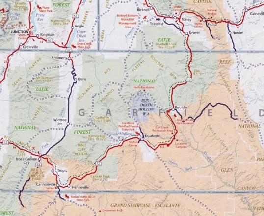
Utah’s Scenic Byway, Route 12

We were told by locals and tourists alike that if we were headed to Capitol Reef National Park, we needed to take Route 12, a scenic byway and All-American Road. A road receives All-American designation by having scenic views unlike any anywhere else, and there are not many roads with this designation.  So, on Monday morning we headed out from Bryce Canyon NP (lower left) to Capitol Reef (upper right center at Torrey) via Route 12.

Route 12 Map.jpg

A guest at the lodge with whom I had a conversation told me it was a spectacular road, with pullouts and special sights all along the way.  He also told me that there was a section of the road which had sheer cliffs on either side.  “I just don’t know why they didn’t put guard rails on that section,” he said.  That was enough to get me going.  I dreaded that section all the way.

The scenery was indeed spectacular and there were sufficient pullouts (that’s what they call them in the west) to give me opportunities for shooting while standing still, something I hadn’t done nearly enough of, it seemed.  I was particularly excited by the heavy cloud formations overhead.  We innocently discussed the possibility of rain on this trip over the mountains.  But, I loved the drama they created and every time I held the camera to my eye, I had a heart palpitation!  Magnificent.

This slideshow requires JavaScript.

But, I kept my eye on the map and the upcoming cliffs with sheer drops and no guard rails.

Route 12 7

It got gloomier, and it was clear we were headed into a storm.  Then, at 9300 feet on our GPS, the snow started coming down, then hail. The road quickly turned white.

Route 12 8

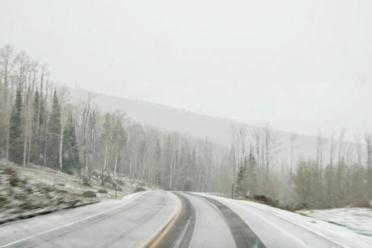
We drove slowly through this squall, meeting a few cars on the way, and every foot of the trip I’m thinking…..we have to drive on this slick road with no guard rails and sheer drops down the mountain.

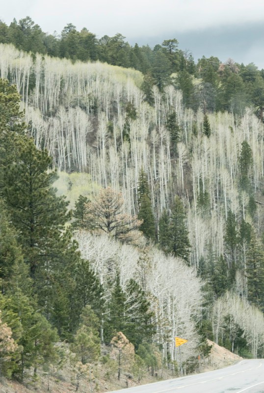
Soon we started getting out of the snow, and things began to brighten.  We started seeing beautiful birch trees with their white trunks and black markings, just beginning to have new yellow-green leaves for the season.  I loved them.  But, I”m still worried.

Route 12 9

Route 12 10

Route 12 11The next thing I know we’re in Boulder, Utah!  Looking at the map, I could see we had passed the dreaded section of road.  I had missed it!  I still don’t know how. I think I must have just “blacked out” when we got there, since I was quite worried about it.  My husband, the driver, says it was a bit scary.  We had hit it before the snow storm and I didn’t even know.

After writing this draft, I decided to google “The Hogback, Route 12, Utah” and found a couple of youtube videos of the drive.  I don’t think I missed it at all!  I think it just wasn’t nearly as scary as I had imagined it would be.  It’s a one-mile section between Escalante and Boulder. Try it for yourself and tell me what you think.

Zion National Park

We made the unfortunate decision to drive into Zion National Park on a Sunday. We left Bryce about 9:30am and arrived at the east entrance around 11am. Traffic was heavy. Looking at a map, we determined that many of the desirable viewpoints in the park were accessible only by the shuttle bus, so we decided to go directly to a parking area and get on a bus. The first obstacle we encountered was getting through the 1.1-mile tunnel near the east entrance. Because it was carved out of a mountain in the 1930s and is fairly narrow, a limited numbers of cars and campers are allowed to go through at a time.  That means that you must wait in a line near the entrance for a time to enter to be made available.  After that 20-30 minute wait, we were through the tunnel and on our way. But, the problem was that the traffic volume in the park was heavy and slow, and when we got to the Visitors Center, no parking was available. We kept moving, never finding parking even in the overflow lots. We never saw more than we could see from the car and a few busy pullouts along the way. We exited through the south entrance, turned around and re-entered, once again waiting to go through the tunnel on the other end and back to Bryce Canyon Lodge. One interesting tidbit.  The roads in the park are colored asphalt, the red color of the rocks in Utah. You can see that in the first photo.

ZNP 13

That said, Zion is a beautiful park.  Unlike Bryce Canyon, you are down among the cliffs.  They are close to you and you are constantly looking up at them.  We regret not being able to go on the shuttle to less accessible areas of the park, but my photos, many of them from the car, will tell you what’s there and how disappointed we were not to see more.  Enjoy.

This slideshow requires JavaScript.


Bryce Canyon National Park, Day 2

Each of Utah’s Mighty Five National Parks is unique in its own way. Bryce Canyon has a rim around which you can walk the canyon, or you can hike or go by horseback down into the canyon. We stayed at the rim on all our visits. The characteristic feature of Bryce Canyon is the Hoodoos. These formations are eroded out of the cliffs where rows of narrow walls form, called fins. With frost cracking the fins and creating windows, eventually the tops collapse and a column is left behind.  Additional impact by rain sculpts these pillars into spires called Hoodoos. Some of the Hoodoos look like people gathering to me.  In one photo you will see rows of Hoodoos, and my husband told me he thought they looked like people in church pews. Look in one of these photos for what I thought looked like an adobe village, with Hoodoos standing in a group on the right.

This slideshow requires JavaScript.

I went out for sunrise at Bryce. When I first got to the rim, I thought I was alone there. But soon I heard male voices talking, even though I never saw them. Gradually more and more people arrived, and I had conversations with several of them. There was serious cloud cover, which can sometimes make a sunrise very special. This sunrise was not spectacular, and many left soon after the light rose over the canyon. I hung on for a bit longer, but it didn’t pay any dividends. However, I loved being there at that time of day.

This slideshow requires JavaScript.

The scenic drive takes you out into the plateau where there is vegetation and a very different look. There are many short hikes along the drive to overlooks with different viewpoints of the canyon. Along that drive we saw evidence of a serious fire, which I learned had occurred last July 2015. Regeneration had begun on the floor of the forest,  but many trees were black and bare.


BCNP Day 2-12BCNP Day 2-5


Bryce Canyon is at an elevation of over 8000 feet, and on the third morning there, I began to experience “Mountain Sickness.” We had been advised early in our planning to drink plenty of water when we were at higher elevations, and we had been doing that for the four days on the road getting to Bryce. But, my symptoms persisted until we left the park and got below 6000 feet. Light-headedness, loss of appetite and nausea, and poor balance all impacted my enjoyment of the park. Fortunately, it reached its “peak” (if you’ll pardon the pun) on the last day, so I was able to enjoy the rim walks and the scenic drive before it hit.

This slideshow requires JavaScript.


Bryce Canyon National Park

I’ve just returned from a wonderful trip out west.  Our primary goal was to see The Mighty Five National Parks of Utah.  We met that goal and more. As a tribute to this year’s 100th Anniversary of the National Park Service, I will show you images from each of the Mighty Five, plus a bonus park, but they will come one blog post at a time.

Our first park stop was Bryce Canyon National Park, where we stayed in a room in the lodge on park property. At check-in, I was told that we had a second floor room with no elevators, and I groaned.  She said, “You have a really great room. All you have to do is walk outside and after a short hike you will be at the rim.”  I didn’t know what to expect, but she was right. It was a really great room. We had a balcony that looked out toward the rim and we could see people walking on the path. We left the building and started up a slight incline through the trees. Near the end of the trail, we could see two guys standing on the edge, one with a camera.

What we saw next took our breath away.  There was the canyon, practically at our back door.

BCNP 3

Everywhere we looked there were spectacular sights. This was late afternoon, and as we walked on the rim, the clouds got heavier and darker.  We never had rain, but in the distance it was apparent someone was getting it. Day Two at Bryce will include sunrise photos and once again some late afternoon shots.  Stay tuned.

This slideshow requires JavaScript.

Hoffman Weigh Station

I live in a rural area and pass many photogenic scenes every time I travel anywhere. This shed is along a secondary road that is on my regular path to many of my activities. I photographed it first on March 25, 2015, after a light dusting of snow made it even more interesting than it already was. I love the trees growing out of it, the turquoise colors on the wood.

Cow shed without cows

A month or so ago, I visited with my friend Joyce who lives on the farm across the road from the shed.  I asked her about it and got some wonderful history.  Her grandfather, Theodore Summerville Hoffman (1874-1963), owned the farm where she has resided off and on for much of her life, and as the owner for the last 36 years. At one time that shed was located on the farm. That parcel was sold several years ago and there is a power transfer station up the road from this shed, behind the trees.

“T.S.” Hoffman, as he was known, raised livestock on his farm.  He also bought livestock from others in the community for a purchaser who lived in Baltimore.  This little shed was the “Weigh Station” for the livestock.  When the cattle were going to be taken to market, they were weighed and measured there, then transferred to the town of Gordonsville, 20 miles away.  In the late 1930s, when my friend Joyce was a child, the cattle were driven by men on horseback to Gordonsville, and then they were put on a train to be taken to Baltimore.  She recalled that after a road was built in the late 1930’s, the livestock were loaded on trucks for transport.

Today I drove by the shed, as I have done many, many times before, and there were cows in the field.  I had to stop to get “the rest of the story.”

Cow shed with cows

Trans-Allegheny Lunatic Asylum

Recently I had an invitation to accompany a friend to the Trans-Alllegheny Lunatic Asylum in Weston, West Virginia.  Also known as the Weston State Hospital, it was built between 1858 and 1881 as a refuge for the mentally ill and criminally insane.  It was originally constructed to house 250 people, but overcrowding and demand led to the construction of additional buildings. It reached its peak population of 2600 in the 1950s.  It closed in 1994 due to changes in the philosophy of how mentally ill people should be treated and because of the physical deterioration of the buildings.

It had to have been a beautiful facility in its heyday.  The architecture is exquisite and the woodwork, molding and colors throughout give you a glimpse of a design that was to provide a peaceful and therapeutic environment.  Today it is easy to feel sad about how it looks, but if you imagine healing the peeling paint, putting fresh curtains on the windows and furnishings in the spaces, it is possible to visualize a pleasant environment.

Let’s take a photographic journey through TALA.

Exterior

The largest hand-cut stone masonry building in North America.

Exterior

The second largest hand-cut stone building in the world, next to the Kremlin.

The second floor has been maintained with many of the original furnishings from the late 19th, early 20th century.

Second floor room-3

Hallway on the second floor of the main building.

Second floor room 2

Parlor on the second floor of the main building.

There was a Community Room where church services and dances were held.  The Weston community high school also held its prom in this room.  There was once crown molding, windows treatments, chandeliers in this space.  It’s beautiful even now.

Community Room

Patient areas in the facility are the ones with the greatest amount of deterioration. Paint is peeling, plaster has fallen, there is rust on metal surfaces.  Most of the windows had bars to secure the patients from harm. The hallways and the rooms were painted bright and beautiful colors:  blue, green, yellow, pink.

Pink meeting room

This is a common area on one of the residential halls. I love the shape of the space, and the light that comes through those windows. In one similar space there was a table with a chess board in the center of the room.

Hallway in blue

A residential hallway, third or fourth floor of the main building.

Bathtub Toilets and sinks

The hospital was a community in itself.  Whatever was needed was available on the property.  Hair salons, medical care, entertainment, gardens, classrooms for instruction in basics for independent living.

Classroom Hair salon Greene hospital room

Patient rooms were sometimes for single individuals, sometimes for as many as four.

This room had four closets, so it is assumed that four people shared this space.

This room had four closets, so it is assumed that four people shared this space.

Window and Radiator

Staff and others who know this building well say it is haunted.  The TV show Ghost Hunters featured this facility in a recent episode. This room is called Lily’s Room. Lily was a child born to patients of the hospital, which happened occasionally.  Many of those children were adopted out of TALA, but Lily stayed there at the request of the nurses, who particularly loved this little girl.  She died at the age of 10 of an illness.  It is believed that her spirit is still in this place, and in this room, so toys are kept there for her.  It is probably also part of the Ghost Tour that TALA conducts at night.

Lily's Room

A few last images.

Cell in Forensics Bldg

A cell in the Forensics Building which housed the criminally insane. These were areas for solitary confinement.

Paintball door

Looks like they may have played paintball on this door.

Window to the outside

The view to the outside from a hallway.

Staircase

Post Navigation

Our Cape Escape

renovation realities

The Mansurovs

Digital Photography Tips, Recipes, Technology and Photographs from The Mansurovs

Perception

Photography. Life.

cookiecrumbstoliveby

Life through the eyes of "cookie"

The Legion of Door Whores

...for those who appreciate doors...

Ray Ferrer - Emotion on Canvas

** OFFICIAL Site of Artist Ray Ferrer **

Belle Grove Plantation Bed and Breakfast

Birthplace of James Madison and Southern Plantation

Leaf And Twig

Where observation and imagination meet nature in poetry.

Firnew Farm Artist's Circle

We meet weekly, and host: Review & Critique of New Works. Our Annual Spring Show is in May and our Annual Fall Show is September - October. Contact: Trish Crowe 540 948 3079

John Berry Photography

Portrait, Sports, Landscape Photographer in Central Virginia

CJ's Workshops

FILM INSPIRES!